

 By
By The Battlefield Is Shaped Before the First Shot Is Fired
Long before an army crosses a border, its fate has already been partly decided by the map. Mountains dictate where columns can march. Rivers decide where bridges must be built and defended. Oceans decide who can be invaded at all, and who cannot. This is the quiet, permanent logic of conflict: armies do not fight in a vacuum, they fight across terrain, and terrain has opinions.
It has become fashionable to assume that satellites, drones, cyberattacks, and precision-guided missiles have erased the old rules. A missile, after all, does not care about a mountain range. A cyberattack does not need to cross a river. Yet look closer at any modern conflict and the same old patterns reappear: the side with better terrain often has the advantage, the side with longer supply lines often struggles, and the side that must fight far from home almost always pays a price that the side fighting near home does not.
Technology changes how wars are fought. It has not changed where they are fought, or which nations are naturally easier and harder to conquer. This article makes the case that geography remains one of the deepest, most underappreciated forces in military strategy — not because it determines outcomes on its own, but because it sets the boundaries within which every other factor, from technology to leadership to economics, has to operate.
1. What Is Military Geography and Why Does It Matter?
Military geography is the study of how physical terrain, climate, distance, and location shape the planning and conduct of war. It sits at the intersection of geography and strategy, asking a simple but consequential question: given the shape of the land and sea, what is actually possible for an army, a navy, or an air force to do?
This is not an abstract academic exercise. Every military plan begins with a map. Commanders study elevation, road networks, river crossings, coastlines, and climate before they study anything else, because these factors determine which operations are even feasible. A brilliant strategy that ignores terrain is not a strategy — it is a wish.
Military geography also shapes national security policy long before any war begins. Nations with exposed borders build alliances and standing armies. Nations protected by natural barriers can afford smaller militaries and different political priorities. A country’s geography effectively writes the first draft of its defense doctrine, and its leaders spend generations either working with that draft or trying to compensate for its weaknesses.
Also Read – Taiwan’s Security Strategy: Challenges, Military Preparedness, and Global Implications..
2. Oceans: Nature’s Greatest Defensive Barriers
No natural feature has protected nations more effectively, or for longer, than the ocean. Water does not merely slow an invading army — it often stops one entirely, because it requires an attacker to build and sustain an entirely different kind of military capability: a navy capable of controlling the sea long enough to move troops, supplies, and equipment across it safely.
The United Kingdom is the clearest historical example. The English Channel and the surrounding seas have shielded Britain from successful invasion for centuries, forcing would-be conquerors — from the Spanish Armada to Napoleon to Hitler’s planned Operation Sea Lion — to first defeat the Royal Navy before they could even attempt to land troops. In each case, failure to achieve naval dominance meant the invasion never happened at all. Geography did not fight the war for Britain, but it defined the precondition every enemy had to meet before the war could even begin on British soil.
The United States enjoys an even more extreme version of this advantage. Bordered by the Atlantic and Pacific Oceans, with relatively peaceful neighbors to the north and south, the continental United States has not faced a serious invasion threat from a hostile major power in the modern era. This geographic isolation allowed the United States to develop its military and economy behind a natural moat thousands of kilometers wide, entering major conflicts largely on its own terms rather than under existential threat at home.
Oceans do more than defend; they also project power outward, but only for nations that invest in naval strength. Control of sea lanes — the maritime highways along which trade, oil, and military supplies travel — has been a defining feature of great power competition for centuries. A nation with a strong navy can protect its own shipping, threaten an adversary’s, and choose where and when to project force. A nation without one, no matter how large its land army, is confined to its own coastline.
Also Read – Is Military Spending Rising Around The World ?
3. Mountains, Rivers and Deserts: Natural Obstacles to Military Power
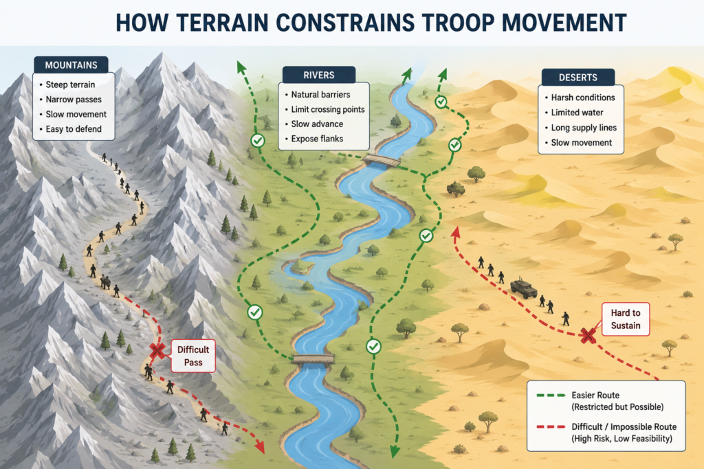
Terrain does not just sit on a map — it actively shapes how armies move, fight, and supply themselves. Three types of terrain in particular have repeatedly proven decisive throughout military history: mountains, rivers, and deserts.
Mountains compress movement into narrow corridors, turning open warfare into a series of chokepoint battles. Afghanistan is the textbook case: its rugged, mountainous interior has frustrated foreign militaries for generations, including the British in the nineteenth century and the Soviet Union in the twentieth, by making it extraordinarily difficult to control territory beyond fortified routes and valleys. The mountains did not make Afghan forces automatically victorious, but they radically increased the cost and difficulty of occupation for any outside power.
Mountain ranges also function as long-term geopolitical dividers. The Himalayas, for instance, form a natural buffer between India and China, limiting the scale and speed at which either country could conduct a full-scale land invasion of the other, and channeling most border tension into specific, narrow contested areas rather than a broad front.
Rivers have historically served as both barriers and highways. A river can stop an advancing army cold until a crossing point is secured, which is why so much of military history is a history of bridges, fords, and river battles. At the same time, rivers have often been used as supply and transport routes, meaning control of a major river system can determine control of the surrounding region.
Deserts, like the Sahara, impose brutal logistical costs on any force attempting to cross them. Heat, lack of water, and scarce infrastructure mean that desert warfare is often decided less by direct combat and more by which side can keep its soldiers fed, hydrated, and fueled. Deserts do not stop movement the way oceans or mountains can, but they punish poor logistics more severely than almost any other terrain.
In all three cases, the lesson is consistent: terrain does not simply sit in the background of a war. It actively decides which routes are viable, which battles are inevitable, and which side bears the greater logistical burden.
4. Strategic Depth: Why Distance Can Be a Weapon
Strategic depth refers to the distance between a country’s borders and its critical centers — its capital, its industrial base, its population centers. A nation with significant strategic depth can absorb an invasion, trade territory for time, and force an attacking army to overextend itself before ever reaching anything decisive.
Russia is the most frequently cited example of this principle in action. Its sheer territorial size has repeatedly turned distance itself into a defensive weapon. Napoleon’s invasion of Russia in 1812 succeeded in reaching Moscow, but the vast distances involved stretched his supply lines to the breaking point, and the retreat that followed devastated his army.
A little over a century later, Nazi Germany’s invasion of the Soviet Union during the Second World War encountered a similar dynamic: the scale of Soviet territory meant that even rapid early advances left German forces increasingly far from their supply bases, exposed to the extension of their own logistics chains and to the onset of a harsh winter for which they were not adequately prepared.
In both cases, Russian territory did not defeat the invading armies by itself. Weather, logistics, industrial mobilization, and the willingness to sacrifice territory all played essential roles. But in both cases, the sheer scale of the land was the precondition that made those other factors possible. Without the distance, there would have been no room to retreat, regroup, and eventually counterattack.
Strategic depth is not only about size, however. It is about the relationship between a country’s borders and what lies behind them. A small nation with mountainous, defensible terrain close to its border can sometimes achieve a version of the same effect that a large nation achieves through raw distance.
5. Islands and Peninsulas: Geography as a Natural Fortress
Islands occupy a special category in military geography because they combine the defensive benefits of water barriers with a level of strategic clarity that few other geographic features offer: to invade an island, an attacker has no option but to cross open water, in force, and survive the crossing.
This is what makes amphibious invasions among the most difficult operations in warfare. They require not just a capable army, but naval superiority to protect the crossing, air superiority to protect the landing force, detailed intelligence about the coastline, and enormous logistical coordination to land and sustain troops without the benefit of existing supply lines on the far shore. Any one of these missing pieces can turn an amphibious assault into a catastrophic failure.
Japan’s island geography has shaped its entire military and strategic history, insulating it from land invasion for most of its existence while simultaneously making naval strength essential to any power projection it might attempt. The United Kingdom, discussed earlier as an oceanic example, is also fundamentally an island nation, and its historical security owes as much to this insular geography as to naval doctrine itself.
Peninsulas offer a partial version of this same advantage. A peninsula is exposed to land attack from one direction but shielded by water on the others, which narrows the number of viable invasion routes and allows defenders to concentrate their forces rather than spreading them across an entire perimeter. Nations occupying peninsulas often develop military strategies built around fortifying a single narrow land approach while relying on naval strength to secure their remaining borders.
6. The World’s Strategic Chokepoints
Some of the most geopolitically important places on Earth are not capitals or industrial centers, but narrow passages of water where global trade and military movement are forced to converge. These chokepoints matter disproportionately to their size because so much of the world’s shipping — and so much of the world’s oil and gas — passes through a handful of narrow straits and canals.
The Strait of Hormuz, between the Persian Gulf and the Gulf of Oman, is the passage through which a significant share of the world’s seaborne oil exports must travel. Any disruption there has immediate consequences for global energy markets, which is why the strait remains one of the most closely watched military flashpoints in the world.
The Strait of Malacca, between Malaysia, Indonesia, and Singapore, connects the Indian Ocean to the Pacific and serves as the primary maritime route for trade between the Middle East, Europe, and East Asia. Its narrowness means that a relatively small naval or military presence could, in theory, threaten to disrupt an enormous volume of global commerce.
The Bab el-Mandeb strait, at the southern entrance to the Red Sea, connects shipping between the Indian Ocean and the Suez Canal, making it a critical link in the trade route between Asia and Europe.
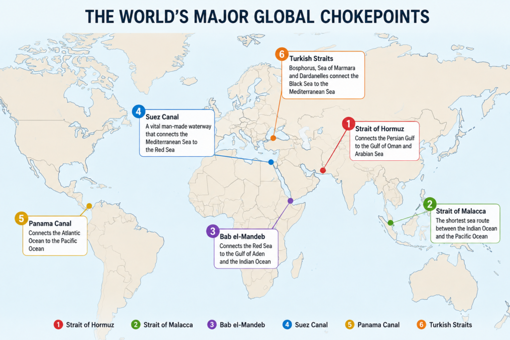
The Suez Canal, connecting the Mediterranean and Red Seas through Egypt, transformed global shipping by removing the need to sail around the southern tip of Africa. Its strategic value was made unmistakably clear during the 1956 Suez Crisis, when control of the canal became the center of an international confrontation involving Egypt, the United Kingdom, France, and Israel.
The Panama Canal, linking the Atlantic and Pacific Oceans through Central America, plays a similar role for trade and naval movement in the Western Hemisphere, allowing ships to avoid the long and hazardous route around South America.
The Turkish Straits — the Bosphorus and the Dardanelles — connect the Black Sea to the Mediterranean and are governed by international agreements that give Turkey significant control over naval passage between the two seas, a position of outsized geopolitical influence given the straits’ relatively narrow width.
Each of these locations demonstrates the same underlying principle: geography can concentrate enormous strategic value into a very small physical space. A nation that controls, or can threaten, one of these chokepoints gains leverage far beyond what its size or military strength would otherwise suggest.
7. Geography and the Rise of Great Powers
The strategic position of today’s major powers cannot be fully understood without accounting for geography, and each case reveals a distinct mix of natural advantage and natural vulnerability.
The United States benefits from oceanic isolation, fertile and extensive agricultural land, access to two major oceans for trade and naval power projection, and relatively secure land borders. Its geography has allowed it to build military strength without the constant threat of land invasion that has shaped so much of European and Asian history.
China has a long coastline and access to major sea lanes, but its naval expansion into the wider Pacific is complicated by what strategists often call the “first island chain” — a string of islands including Japan, Taiwan, and the Philippines that constrains China’s direct access to open ocean and gives potential rivals a natural line of surveillance and defense. China also shares land borders with numerous countries, some historically contentious, adding a layer of continental security concerns that purely maritime powers do not face to the same degree.
Russia possesses the largest landmass of any nation, giving it exceptional strategic depth, but much of that territory is difficult to develop, sparsely populated, or covered in severe climate for much of the year. Russia has also historically lacked reliable year-round warm-water port access, a limitation that has shaped centuries of its foreign policy and repeated efforts to secure access to the Black Sea and beyond.
India is partially shielded from land invasion by the Himalayas to the north, giving it a natural buffer against its largest neighbor, but it faces more open and contested land borders to the west and remains highly exposed along its extensive coastline, requiring it to balance land-based and maritime security simultaneously.
| Power | Key Geographic Advantage | Key Geographic Vulnerability |
|---|---|---|
| United States | Ocean isolation, two-ocean access | Long-distance power projection required for overseas operations |
| China | Long coastline, large population base | First island chain limits open-ocean naval access |
| Russia | Enormous strategic depth | Lack of reliable warm-water ports, harsh climate |
| India | Himalayan buffer to the north | Extensive coastline and open western land border |
None of these advantages or vulnerabilities is fixed forever, but all of them are slow to change, which is precisely why geography functions as such a durable strategic factor. Economic policy can shift in a single election cycle. A mountain range does not move at all.
8. Logistics: The Geographic Reality Behind Military Power
Behind every battle is a far less dramatic but equally decisive struggle: the movement of fuel, food, ammunition, and equipment to the soldiers who need them. Logistics is where geography and military power meet most directly, because every supply route must physically cross real terrain, and every port, railway, and airfield exists in a specific place for specific geographic reasons.
An army with brilliant tactics but broken supply lines will eventually stop fighting, not because it lacks courage or skill, but because it runs out of what it needs to function. This is why controlling ports, railways, and airfields is often as strategically important as controlling territory itself — they are the physical infrastructure that turns raw military potential into sustained fighting power.
Geography determines which supply routes are even possible. Mountain ranges restrict roads to a handful of passes. Deserts demand fuel and water convoys far beyond what temperate terrain requires. Rivers and coastlines determine where ports can be built at all. This is the unglamorous, often-overlooked layer of warfare where geography exerts perhaps its most consistent influence: not in the drama of the battlefield, but in the quiet arithmetic of what can physically be delivered, and where.
9. Has Modern Technology Made Geography Less Important?
It would be reasonable to assume that long-range missiles, drones, satellites, and cyber warfare have reduced the importance of geography. In some respects, this is true. A long-range missile does not need to cross a mountain range on foot. A cyberattack does not care about ocean distance. Satellite reconnaissance can observe terrain that once required dangerous physical scouting.
But this technology has not eliminated geography’s role — it has changed the form that role takes. Every advanced military system still depends on physical infrastructure that exists in specific, geographically constrained locations. Precision-guided missiles still require secure bases from which to launch. Satellite networks still depend on ground stations built in particular places. Global data and communication still travel largely through undersea cables that follow specific, mappable routes across ocean floors, making them both a critical asset and a potential vulnerability. Drones require runways, control stations, and supply chains for parts and fuel.
In other words, technology has not made militaries independent of geography — it has made them dependent on a new and expanded set of geographic assets: forward operating bases, satellite ground stations, cable landing points, and secure logistics hubs. A nation seeking to project modern military power still needs physical locations from which to do so, and the location of those assets is still governed by the same old questions of distance, terrain, and access that have always mattered.
Perhaps the clearest way to state the relationship is this: technology has expanded what nations can do despite distance, but it has not removed the underlying cost that distance imposes. Long-range power projection remains more expensive, more complex, and more logistically demanding than operating near one’s own borders, no matter how advanced the technology involved.
Read – Great Power Competition and Cyber Conflict
10. Geography Does Not Guarantee Victory
None of this should be read as an argument that geography alone decides who wins a war. History offers plenty of examples where the side with the geographic advantage still lost, because geography is only one input among many that determine military outcomes.
Leadership matters enormously — a poorly led army can squander even the best terrain, while a well-led force can find creative ways to offset a geographic disadvantage. Economic strength determines how long a nation can sustain a war effort once natural advantages have been factored in. Industrial capacity determines whether a country can replace losses and continue producing the weapons and equipment its forces need.
Alliances can offset geographic isolation or vulnerability by providing bases, resources, and reinforcements that a nation could not generate alone. Morale and political stability determine whether a population and its military are willing to endure the sacrifices that war demands. And strategy — the human decisions made about how to use available terrain, forces, and resources — ultimately determines whether geographic advantages are exploited or wasted.
Geography, in this sense, functions less like a guarantee and more like a set of odds. It tilts the table in certain directions, makes some outcomes more likely and others less likely, and imposes real costs and constraints on military planning. But it does not remove human choice, human error, or the countless other variables that determine how a conflict actually unfolds.
11. FAQs
How does geography affect military strategy?
What is strategic depth in military terms?
Why are oceans considered a natural military defense?
What are the world’s most important military chokepoints?
Has modern technology made geography less important in war?
Does geography guarantee victory in war?
Why is Russia considered to have significant strategic depth?
12. Conclusion: Geography Still Shapes the Limits of Power
Wars are fought with the weapons of the present, but they are still fought on the terrain of the past — the same oceans, mountains, rivers, deserts, and chokepoints that have shaped military strategy for centuries. Nations can build extraordinary new technology, train highly capable militaries, and forge powerful alliances. What they cannot do is change their location, redraw their borders, relocate their mountain ranges, or manufacture direct access to the sea where none exists.
This is why geography remains such a durable force in military strategy, even in an age of satellites and cyber warfare. It does not act alone, and it does not guarantee outcomes. But it sets the stage on which every other factor — technology, leadership, economics, and strategy — must perform. Technology may transform the battlefield, but geography continues to define the strategic environment in which every military power must operate.
What do you think? Comment below..
